About
HARMONIC at a glance
HARMONIC
Harmonization of Actions and Reforms on Mobility and Organization in New Interactive Cities.
Main axis
Enabling the development of tools and methods to optimise decision-making
Secondary axes
- Improving knowledge on the mobility of people and goods
- Making progress in mobility data collection and processing
Leading institution
CY Cergy Paris University
Scientific coordinator
de Palma André, Emeritus Professor, CY Cergy Paris University
Project duration
48 Months
Kick-off meeting
September 12, 2025
This project is funded by ANR - the National Research Agency-.
Presentation of the project
The HARMONIC project “Harmonization of Actions and Reforms on Mobility and Organization in New Interactive Cities,” focuses on evaluating transport and urban development policies. The project's primary goal is to ensure that these policies are better calibrated and harmonized.
A sustainable development strategy must balance environmental, social and economic objectives. However, policies that advance one goal may harm others. This is especially true for mobility policies. For example, low-emission zones (LEZs) reduce air pollution, providing environmental benefits, but they may also exacerbate social inequalities by disproportionately affecting low-income populations who are more likely to own older, non-compliant vehicles. These conflicting impacts highlight the need for adjustment and fine-tuning of policies. Furthermore, different policies may produce adverse effects. For example, promoting electric vehicles or autonomous vehicles could lower the average and marginal costs of travel, influencing household location choices. This might encourage urban sprawl as households look for more affordable and spacious (and thus less energy-efficient) homes farther away from the city centre. In contrast, LEZ policies could induce urban densification for households locating closer to public-transit hubs. Therefore, harmonization between policies is crucial to ensure that they collectively support sustainable development goals.
The goal of HARMONIC is to analyse the short-run (e.g. automobile ownership or mode choice) and long-run (e.g., household and firm locations) impacts of various policy combinations. The period of study is 2025-2050. Our analysis will rely on METROPOLIS2, a dynamic agent-based traffic simulator, and EUrbanSim, a dynamic land use model. We previously developed these unique tools, and will extend and interact them, along with several other tools developed by HARMONIC partners. The focus will be on the cross-effects of different policies and trends. For example, how is the rise of electric vehicles compatible with the introduction of new public transit lines? These policies have been evaluated individually. A radial public-transit line can have centripetal effects, while a reduction in kilometre costs (as is the case with electric vehicles compared to thermal vehicles) can lead to urban sprawl. Similarly, the zero net land artificialization (ZAN) legislation can conflict with other policies, such as the development of transport infrastructure: the construction of new tramway, metro, or bus lines can sometimes require land artificialization, especially on the outskirts of cities. Densification can also lead to tensions regarding quality of life, green space management, and public services. To sum up: combining economic development with decarbonization of the society remains a huge challenge.
To meet our policy harmonization challenge, we will build an operational dashboard for evaluating the combined effects of a wide range of transport and urban policies. The dashboard will facilitate discussions with stakeholders to determine the best ways to harmonize policies, taking into account the short, medium and long run time scales.
Project outline
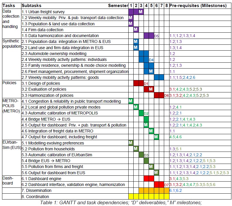
The project is structured into 32 interconnected subtasks (detailed in Table 1), grouped in 8 tasks (including dissemination and coordination), as briefly described below.
Data Collection (Task 1): Collection of a wide range of data on population, firms and land use data, plus an original survey on urban freight and weekly mobility.
Synthetic Population (Task 2): Building synthetic populations of individuals, firms, buildings, private vehicles, and trucks evolving over time, using Task 1 data. All synthetic populations are used both in our simulators METROPOLIS2 and EUrbanSim, and for illustrating our theoretical developments.
Policies (Task 3): Design (to feed simulators), evaluation (using our simulators outputs), and harmonization of various policies such as electric cars, automated vehicles, SERM, low emission zones, and zero net soil artificialization, to ensure the optimality of their interactions.
Model Development and Calibration (Tasks 4 & 5): Further developments and adaptation of our transport and land use models, including evolving preferences and automatic calibration. METROPOLIS2 and EUrbanSim are integrated, and jointly used to evaluate policies.
Dashboard (Task 6): dashboard engine and interface to manage inputs/outputs of policies.
Dissemination (Task 7): Dissemination of the results and insights gained from the project.
Coordination (Task 8): Ensuring effective coordination of our highly interconnected tasks. The main study areas of HARMONIC will be Île-de-France and in Strasbourg Métropole.
Scientific strategy
The framework of our work is straightforward: data collection, policy definition, simulation using an integrated tool for transport and land use, representation of policies affecting short-term choices (weekly mobility) and long-term choices (urban development). Our main ultimate goal is to identify ways to harmonize policies to avoid redundancies and contradictions and to improve synergies. We add various crucial complexities: (1) considering decisions within families; (2) accounting for changes in preferences; (3) considering mobility on different days of the week; (4) integrating freight transport.
The main innovative scientific contribution of HARMONIC is the integration of different tools in a unified framework combining data production and collection, theoretical developments (micro and public economics), econometrics (structural models), data science (for the automatic calibration), and engineering (on the supply side). The synthetic populations will offer a bridge ensuring consistency between the different simulators, and allowing to compute the behavioural and redistributive effects of the policies evaluated and harmonized, both in the short run and in the long run. Crucial guidelines will be provided by the stakeholders and other practitioners, and by the field knowledge of several participants in the consortium. The consortium has demonstrated its expertise in each of the component tools, models and subject areas in HARMONIC. Each component will be fine-tuned and enriched in order to better integrate it with the other components. Consortium participants who are not specialized in a given component will bring fresh eyes and insights to aid the specialists.
Challenges
At first glance, HARMONIC may look too ambitious. However, the main challenge is not to perform individually each of the developments considered, but rather to integrate them. Our first challenge is thus to ensure that the work of each team/discipline aligns with the needs and expectations of the others. Our numerous past collaborations, and the careful management of the project (see 2.1.2) will allow us to meet this challenge. Drafting this proposal was our first exercise in alignment. Each of the 4 items listed in 2.1.3 is innovative and, as with any research, contains some uncertainty. Nonetheless, with specialists in each of these areas on our team, the major remaining challenge will be to integrate them into a unified framework and demonstrate the benefits of studying them. The consortium as a whole offers a spectrum of solutions large enough to address each specific source of uncertainty or unexpected obstacle. Some specific technical challenges may be mentioned. We rely on two main models: the land use model describes the dynamics of the long run evolution of the urban system (slow adjustment process); the traffic model computes short run stationary solutions (fast adjustment process). The challenge is thus to reconcile these two fundamentally different time scales. We will meet this challenge by consistently integrating the two models, using synthetic populations carefully built for this purpose. When evaluating the long-run effects (typically up to 2050) of transport and urban policies, account should be taken of changes over time in both preferences (e.g., attitudes towards non-motorized modes) and technology (e.g., teleworking, electric cars and autonomous cars). To meet this challenge, we will use panel data techniques to measure the trends of such evolutions and, where needed, exploit experimental economics data already collected by HARMONIC partners. Finally, the quality of the results depends on the quality of the data. In Task 1, we rely mainly on open data (national and local travel surveys, OpenStreetMap networks, Census, TomTom free access, and land occupation data) and on data collected internally (for freight and weekly activity).
Rationale for this consortium
We established an interdisciplinary and highly complementary consortium including economists (BETA and ThEMA), computer scientists (LIVE and ThEMA), geographers and physicists (LIVE), land planners (IPR and MATRiS), engineers (LVMT and SPOT), industrial engineering (BETA).
Three external participants (N. Geroliminis, P. Stokkink, R. Lindsey) will strengthen our international scientific excellence. Most participants have already worked together and/or published together, which will make it easier to break down the interdisciplinary barriers, usually difficult to overcome.
Scientific and technical description of the project
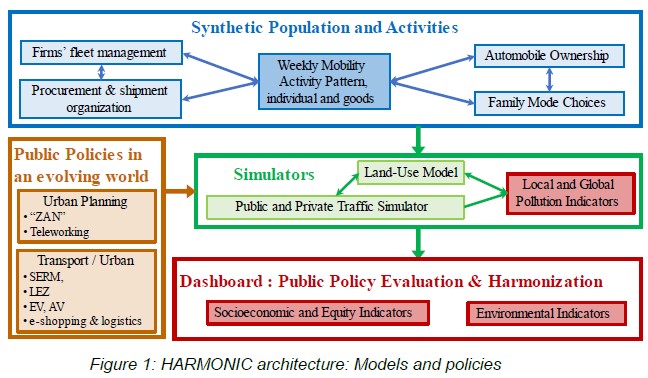
Figure 1 describes the four modules of HARMONIC: (1) Synthetic populations and activities for freight, private, and public transportation, including decision trees for ownership, trip chaining, and family-level itineraries; (2) Simulators for transport, land use, and pollution: develop, calibrate, and run our tools; (3) Policy scenario construction, evaluation and harmonization; and (4) Dashboard for presenting results. The corresponding (sub)tasks are described below and detailed in Table 1.
Data collection and handling
Two critical types of data are largely overlooked in the literature: the day-to-day variability of mobility and freight transport. We will collect and analyze such data to integrate them into our research.
Weekly mobility. IPR has developed a unique database for the Île-de-France region, EMG2023, detailing the trips of 3,337 residents who agreed to carry a GPS tracker recording their movements for 7 consecutive days. The survey employs an innovative methodology, combining an initial online survey (participant’s socio-economic characteristics and travel habits), a 7-day GPS tracking, a daily logbook, and a follow-up phone verification. The resulting mobility database, comprising approximately 81,000 entries, will allow a comprehensive analysis of 7-day mobility patterns, offering a fresh perspective beyond the traditional average weekday. The results will feed the traffic simulator, METROPOLIS2.
Urban freight data is essential for developing the freight model in the HARMONIC project. Unfortunately, recent urban freight data, particularly concerning urban B2B freight flows, is lacking in France. To address this gap, we will conduct a new survey to calibrate freight transport demand and shipment generation in SOLID (see details in Abed, et al. 2014). To conduct this survey, a new framework for frugal Urban Goods Movement Surveys (UGMS) will be developed. Our objective is to design and test a new standard that makes UGMS simpler, cheaper, and more feasible. We hope that once this new standard is proven in the HARMONIC project, it will be adopted by local authorities—potentially with the endorsement of the French Ministry of the Environment or CEREMA—enabling more frequent UGMS and a rapidly expanding data corpus over time.
Synthetic population
In METROPOLIS, the traveling population is represented as a list of agents with specific characteristics, derived from a synthetic population. Each agent has a plan of trips to undertake, taking into account available travel modes and preference parameters. We will generate such synthetic population by adapting and expanding the methodology of Hörl and Balac (2021), e.g. by incorporating car ownership and weekly mobility. We will build a consistent synthetic population for households and firms to study long run decisions in EUrbanSim. This will be studied by a PhD student supervised by N. Picard and M. Bierlaire (Anderson et al. 2024).
Weekly mobility
After a thorough analysis of weekly mobility based on the EMG 2023, we will model daily trips, which involves selecting the travel day. We will thus add to the classic "4-step" traffic forecasting model a 5th step (departure time choice, specific to dynamic models) and a 6th step (choice of the day). This 6-step processing chain is: (1) Choice to travel (generation) (2) Choice of travel day (3) Choice of destination (distribution) (4) Mode choice (5) Choice of departure time (6) Route choice (assignment). Some steps could be combined and looped between each other. Accessibilities, or “logsums” will be used as intermediate tools to construct a nested logit model (some of these accessibilities can be usefully represented in the dashboard).
Automobile ownership and family choice
We will develop a disaggregated heterogeneous equipment choice model, focusing on household decisions to buy, lease, or rent vehicles. The model will be calibrated using aggregate data provided by the CCFA (Comité des Constructeurs Français d'Automobiles) or INSEE, among others. Vehicle ownership at the family level will be determined using a decision tree: ownership at the upper level, and mode used for the primary activity (and possibly other activities) of each household member at the lower level. We will also develop a Stackelberg model with an endogenous leader and follower to estimate the probability of leadership of each spouse, and compare its predictions with our collective model (Picard et al., 2018). In addition, the joint residential and job location model of Inoa et al. (2015) will be extended from singles (one decision maker) to dual earners households (several decision makers), taking into account interactions between spouses and car ownership (see sections 1.2.8 and 2.2.2.1).
Trucks transport
We will build on SPLOTT’s previous work with the SOLID model and develop a module for synthetic population of firms in urban areas (Abed et al., 2014), as part of a PhD project. Our goal is to leverage open data and/or administrative statistics, combined with econometric, optimization, or artificial intelligence methods, to simulate a realistic and precise synthetic population of firms. These firms will be characterized by various attributes that serve as inputs for the SOLID model (as well as EUrbanSim), including company size and network, vehicle fleets, operating hours, and more. The accuracy of this input is crucial, as it enables more precise estimation of costs and operational constraints for agents, thereby reducing errors in choice modeling that can arise from poor input data. Additionally, this work on synthetic populations will enhance our understanding of agents' choices when facing explicit constraints. Specifically, we will examine the factors influencing fleet management decisions for firms within the context of increasing emission regulations, and determine how these factors can be integrated into our agent-based simulation.
Vehicle fleet trend
We will analyze the determinants of household vehicle ownership and choice of vehicle type to assess the social and environmental effects of policies analyzed. IPR will contribute to this modeling by complementing it with its vehicle fleet forecasts in Île-de-France. To model scenarios for the metropolitan Low-Emission Zone (ZFE), such as exemptions, and to evaluate their territorial and environmental impacts, we will distinguish between private and professional vehicles, take into account light commercial vehicles, consider the structure of the fleet by Crit’Air sticker, and account for the sales of new electric vehicles at different time horizons (2025, 2027, 2030) as well as the growth of the used electric car market. Additionally, the EMG 2023 will be used to generate a synthetic population by municipality and to assign an automobile to each household.
Relation with PERP MOBIDEC
The dataset for freight will be made available to the academic community through the Mob Sci-Dat Factory platform (FP3 of MOBIDEC PEPR). + NC, FC, LG, AB
Planning, KPI and milestones
HARMOMIC is a 4-year project (8 periods of 6 months), as outlined in the Gantt diagram (Table 1). Tasks are conducted in parallel, whereas most subtasks in one task are conducted in series. Deliverables marked “D” provide the main results, while milestones are marked by a white “M”. The 8 tasks are intricately dependent on each other: extensive data collection and harmonization (1), used in synthetic population task (2) including detailed modeling; policy design and evaluation (3) relying on two interacting simulators (4 and 5); our dashboard development (6) is the main output of the project for policy makers; dissemination (7) and coordination (8) are conducted throughout the project. Transport, pollution, inequalities and public policy evaluation are transversal to the project.
Expected outcomes of the project
Scientific expected outcome
Publications of articles in transport economics, urban economics, geography, regional sciences, energy, environment, social choice and policy analysis. We aim to publish at least eight articles in top-tier journals, with two or three in prestigious publications (Science, Nature, Nature Communications, Nature Climate Change or PNAS). Other papers will be aimed at top field journals. We will write 2 position papers (see 3.3.3). Articles will be submitted to The Conversation, or as IPR’s Note rapide. Our results will be accessible to policymakers through our dashboard (see details in section 2.2.6). We will also produce a few videos, accessible from our website and YouTube aimed at policy makers and at an educated general public. In section 3.3.3, we describe the valorization of our activities.
Valorisation and Transferability to other French cities
The bi-monthly online transport and land use seminar, originally established as part of the ANR AFFINITE project, will be renamed HARMONIC seminar. It is open to students and faculty in France, Europe, and North America. This seminar will feature ongoing research by project participants, as well as by other researchers working on similar topics. The presentations will be recorded, and sufficient time will be allocated to discussion (the seminar lasts 1.5 hours, including questions). Starting in year two, we will offer an online course on METROPOLIS. Starting in year three, it will be completed supplemented by an online course on urban modelling. The two courses with be consolidated in the last year (with possibly the organization of a summer course, to meet potential demand). The idea is to: (a) teach young scholars and practitioners how to use our tools, and (b) identify future partners who can use our platform for other cities. A trial online course (10 3-hours sessions), attended by 15 international students was offered by L. Javaudin in Spring 2024, for METROPOLIS2.
The automatic calibration of METROPOLIS2 and EUrbanSim, along with their integrated version, will enable within a few months to perform simulations for any city or region in France. The tool primarily relies on synthetic populations generated from open data available for all French cities. With minimal additional work, policy evaluations could be extended beyond Paris and Strasbourg to other cities. Throughout the project, we will identifying local partners and encourage collaborative efforts in these directions. Our goal is to create a platform accessible to other interested parties. This process is currently more standardized for the short-term traffic model than for the urban long-term component.